
Wald am Arlberg - Spullersee - Klösterle | Wald am Arlberg
Distance12,3 km
Elevation gain869 m
Negative altitude810 m
LevelModerate
Duration6:00 h
Distance12,3 km
Elevation gain869 m
LevelModerate
Duration6:00 h
A short moment
Loading map...
Wald am Arlberg - Spullersee - Klösterle | Wald am Arlberg
The tour starts at the bus stop "Wald Gasthaus Spullersee" in Wald am Arlberg. From here, past the Spullersee Karftwerk, you walk a short distance along the road into the valley. Before the Spreubach bridge, the hiking trail branches off to the left. From here, the hiking trail leads over several bridges and ravines, always uphill towards Spullersee. After about 2.5 hours you reach the picturesque Spullersee in the Lechquellen Mountains. The circular trail around the Spullersee is easy and the lakeshore is a good place for a short rest before returning downhill via the Alpe Grabs/Spullers. First follow the hiking trail, then a bit along the goods path and the last section of the tour is then along the Wäldletobel down to Klösterle am Arlberg. Return to the starting point with the bus line 720 to Wald am Arlberg.
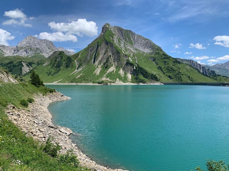 Malerischer Spullersee
 Wanderwegenetz Vorarlberg

Equipment
Sturdy shoes, warm clothing, rain and sun protection, filled water bottle and small snack as well as hiking poles are recommended. Mobile phone in case of emergency.
Route description
Start: Bus stop "Wald Gasthaus Spullersee", Wald am Arlberg
End: Bus stop "Schulhaus Klösterle", Klösterle am Arlberg
Bus stop "Wald Gasthaus Spullersee" - along the road briefly into the valley - hiking trail branches off to the left - Spreubach - turn off towards Spullersee - mountain hiking trail - Spullersee - circular trail around Spullersee - descent via Alpe Grabs/Spullers - goods trail - Wäldetobel - Klösterle am Arlberg - bus stop "Schulhaus Klösterle" - bus line 720 back to Wald am Arlberg.Properties
- Linear route
- Scenic
Emergency services
140 Alpine Emergencies throughout Austria
144 Alpine Emergencies Vorarlberg
112 Euro emergency call (works with any mobile phone/network)